





20-year strategy risks
failing the community
The Central Coast Council’s newly minted 20-year land-use framework, anchored by its comprehensive Local Strategic Planning Statement (LSPS), marks a critical turning point for a region caught between rapid metropolitan expansion and environmental vulnerability. Tasked with mapping out the physical spatial footprint of a region projected to absorb tens of thousands of new residents, the council has delivered a highly detailed roadmap. It explicitly dictates where new boundaries will be drawn, where concrete will be poured, and how growth corridors will connect Gosford to northern hubs like Wyong and Tuggerah.
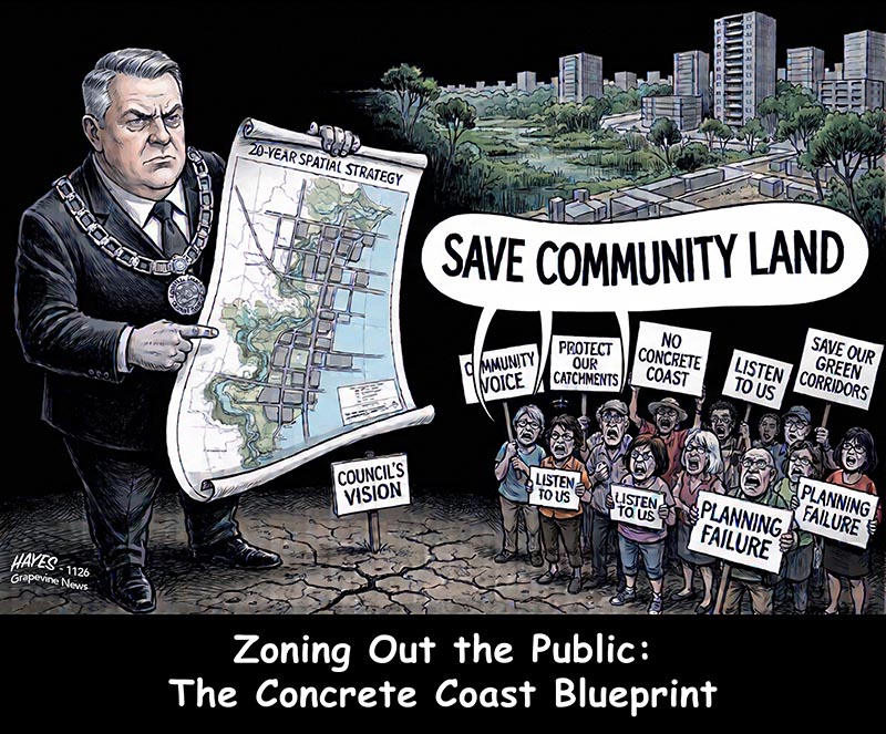
Yet, beneath the polished maps, glossy infographics, and high-level terminology lies a widening rift between the civic bureaucracy and the people who live here. As the strategy moves from public exhibition into institutional policy, it faces intense resistance from local advocacy groups, community forums, and residents. The emerging consensus among critics is clear: the council’s blueprint treats planning as a clinical exercise in spatial mapping rather than a dynamic social and ecological contract. Critics argue that the public consultation process systematically muted the community’s voice, leaving residents with a tokenistic seat at a table where major decisions had already been finalised.
If the Central Coast is to avoid turning into an unlivable, congested northern suburb of Sydney, its core strategy must do far more than simply allocate space for growth. It must actively protect the unique character of the region and guarantee that local voices genuinely shape the decisions impacting their neighbourhoods.
11 November 2026
ALAN HAYES
AT its core, the Draft Central Coast Local Strategic Planning Statement (LSPS) is designed to solve a numbers game. Driven by state government mandates to alleviate Sydney’s severe housing crisis, the document establishes clear baseline targets for the region: the accommodation of over 75,000 new residents, requiring the rapid construction of at least 41,500 new dwellings and the creation of roughly 24,000 new local jobs by the conclusion of the planning cycle.
To achieve this, the council has relied heavily on zoning adjustments, high-density growth corridors, and sub-regional structure plans like the Draft Greater Lake Munmorah Structure Plan. The strategy divides the Coast into distinct functional zones:
- The Southern Corridor: Stretching from Somersby to Erina, designated primarily for economic activation, commercial investments, and employment growth.
- The Northern Growth Corridor: Spanning Tuggerah, Wyong, and the emerging Warnervale sector, targeted for heavy residential densification.
- The Regional Capital: Positioning downtown Gosford as the high-rise civic and economic anchor of the entire local government area (LGA).
While this orderly distribution looks clean on a master plan, local community advocates argue that it exemplifies the document's greatest vulnerability: an over-reliance on spatial geometry at the expense of genuine ecological and social infrastructure.
A sustainable region cannot be built by merely overlaying lines on a map to indicate where developments can be built. True strategic planning requires binding, enforceable policies that run parallel to land allocation. It means ensuring that when a zone is reclassified to allow a block of units, the funding, design, and construction of expanded schools, local hospitals, accessible green corridors, and public transport networks are legally locked in simultaneously.
By treating the LSPS primarily as a tool for spatial growth management, the council risks repeating the mistakes of Western Sydney’s rapid development. This approach risks creating sprawling urban developments that are isolated from essential services, heavily car-dependent, and detached from the natural landscape that defines the Central Coast's identity.
The environmental blindspot: Missing maps and phantom targets
The most significant criticism of the council’s long-term strategy focuses on its handling of environmental conservation. The Central Coast’s primary competitive advantage and its main draw for residents is its natural environment—the unique intersection of pristine beaches, sensitive coastal lagoons, and dense hinterland bushfire-prone forests.
The community has made it overwhelmingly clear that protecting this landscape is their absolute highest priority. However, a formal analysis by the Community Environment Network (CEN) revealed significant gaps in the strategy's environmental protections:
- Exclusion of the Coastal Open Space System (COSS): Despite the council openly acknowledging that the community views the preservation and expansion of the COSS as a non-negotiable priority, early versions of the strategy failed to include comprehensive, dedicated mapping of COSS boundaries.
- Lack of Funding Pathways: The document mentions conservation as an abstract ideal but avoids outlining explicit, legally binding funding models or developer contribution mechanisms required to acquire and protect these sensitive parcels of land.
- Absence of Climate and Biodiversity Metrics: While the plan lists "sustainability" as a core pillar, it lacks verifiable baselines, definitive carbon reduction goals, or clear urban tree canopy targets.
By failing to integrate environmental maps directly into the spatial planning document, the council has inadvertently created a hierarchy where development zones are explicitly defined, while conservation areas remain vague and unprotected. This imbalance leaves the region's highly sensitive water catchments and critical wildlife corridors vulnerable to incremental developer encroachment and ad-hoc re-zoning proposals.
Community advocate Joy Cooper said "A 20 year strategic framework running through to 2046 must do more than simply map out spatial growth, it must reflect the true aspirations of our entire community, safeguard our built identity, and deliver infrastructure equity across every corner of our LGA.
"Regrettably, there is a clear disconnect in how this draft was developed. Genuine community consultation has felt secondary, while it is hard to ignore the extremely thin veil hiding the outsized influence of select 'high rollers' and major commercial interests in shaping the strategic direction. A genuine 20 year plan must belong to the whole community, not just a privileged few.
"Nowhere is this disconnect more evident than in the treatment of built heritage. The draft strategy reduces the rich history of Gosford to a single generalised sentence, completely omitting our iconic 1969 former Gosford Library building in Kibble Park. This mid century civic landmark is recognised by the National Trust and the Australian Institute of Architects, and is currently undergoing formal assessment for local heritage listing.
"An extraordinary coalition of 34 local community organisations co signed an open letter calling for its retention and adaptive reuse. Leaving it out creates a dangerous policy vacuum that risks demolition by neglect. The final LSPS must explicitly recognise the former Gosford Library as a key civic asset to be retained for community use.
This skewed focus also leads to baffling infrastructure priorities. Why does the draft focus heavily on already fully serviced commercial streets in Erina, while high traffic pedestrian corridors like Aston Road are completely ignored despite broken footpaths and no street trees to safely connect Springfield and East Gosford residents? Equally glaring is the total omission of Key Enabling Projects for the Woy Woy Peninsula, such as resolving the Rawson Road level crossing, despite expecting the area to absorb significant housing density.
"A 20-year strategy must deliver statutory accuracy and environmental leadership. Council must audit its spatial mapping to ensure private property (such as Cooney Reserve in Erina) isn't misleadingly presented as public reserves. Furthermore, Council must honour the promise of amalgamation by expanding our visionary Coastal Open Space System (COSS) into the former Wyong Shire, backing passive land acquisition with active resourcing for weed eradication, enforcement against illegal dumping, and reserve maintenance at sites like Kincumba Mountain.
"To deliver a 20-year framework that earns the trust of the Central Coast, Council must amend the final LSPS to protect our history, balance infrastructure equity, correct mapping errors, and expand COSS northward for generations to come."
Historian Merril Jackson said that a LSPS is intended to be our region's authoritative blueprint, providing clear and enduring guidance for the next 20 years. "It must give certainty to developers, state government and the broader community, articulating not only how our region will grow, but what we, as a community, value and seek to preserve.
"Yet this LSPS contains a critical absence precisely where our history, heritage and identity should be represented."
A representative of GUST (Grow Urban Shade Trees) said "If Central Coast Council were to set comparable targets, they would require structural changes and vast additional resources. Backed by an undisputed body of evidence and warnings from the AMA around planning for heat, GUST believe these changes need to be a priority.
"Critically, all these measures require resources. Central Coast Council still lacks an adequately staffed, dedicated team and lacks funding for urban green requirements for a local government area of our large scale."
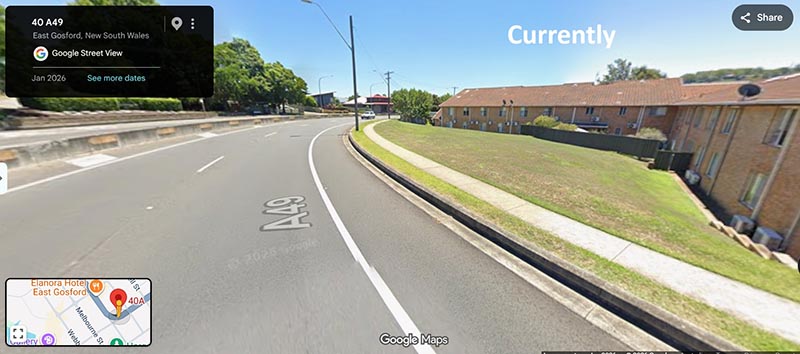
Existing streetscape East Gosford.
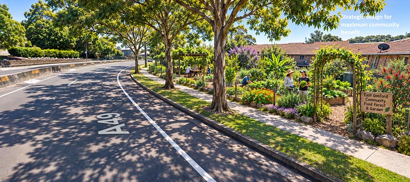
Solar mapped and planted for heat mitigation.
Simple changes make a powerful difference. Green infrastructure is a specialised field requiring technical expertise. It needs to be properly funded and integrated into Council's "business as usual" and not simply left to untrained and unfunded volunteers.
Muted microphones: Why the community voice was sidelined
The tension surrounding the 20-year strategy is deeply exacerbated by a flawed public consultation process. While the council pointed to its online portals, digital feedback surveys, and local pop-up sessions as evidence of broad community engagement, local community groups paint a very different picture. They describe a process that felt more like a corporate marketing campaign designed to manage public reactions, rather than a genuine, democratic conversation.
The fundamental breakdown in community consultation stems from several structural barriers:
- Pre-Determined Agendas: Public hearings and feedback sessions were tightly structured around pre-determined options. Residents were rarely asked if or how certain areas should grow; instead, they were asked to choose between pre-selected density variations, rendering fundamental objections impossible to record.
- Information Asymmetry: The documentation made available to the public was thousands of pages long, filled with complex planning jargon, and supported by confusing or inaccurate mapping data. Without independent technical advocates, everyday residents were placed at a severe disadvantage when attempting to challenge expert testimony presented by major developers.
- The Institutional Consultation Gap: The long-standing absence of an elected local council during crucial stages of the strategy's formulation left an institutional void. Decisions that will shape the region for a generation were handled by state-appointed administrators and unelected planning panels, removing the direct democratic accountability that keeps local government responsive to its community.
When public feedback is reduced to checking boxes on online surveys or dropping digital pins on highly restricted maps, the resulting policy cannot claim to reflect the community's true vision. The widespread public frustration across the Central Coast stems from a clear realisation: while the community spoke loudly and clearly, the administrative framework was structured to ensure their input had no real power to alter the pre-determined plan.
Blueprint for failure: The risk of over-promising and under-delivering
If the council continues down its current path, ignoring community pushback and treating the LSPS as a simple land-allocation exercise, the strategy faces three highly predictable structural failures over the next two decades:
- The Infrastructure Lag: The current strategy relies on the optimistic assumption that state agencies will automatically deliver schools, roads, and hospitals to match local rezoning. History shows the opposite occurs: residential developments are completed rapidly by private developers, while essential public infrastructure lags years behind. The northern growth sectors are already seeing severe traffic congestion, school overcrowding, and long wait times at regional medical facilities—issues that will only intensify without mandated infrastructure funding links.
- The Loss of Regional Character: By focusing heavily on density targets and 15-to-30-minute connected urban centers, the plan risks eroding the unique suburban and semi-rural character that defines the Central Coast. If medium and high-density developments are pushed forward without strict, character-preserving Development Control Plans (DCPs), distinct coastal villages risk being transformed into generic, continuous urban sprawl.
- Economic Disconnection: The plan places a heavy emphasis on creating 24,000 new local jobs to reduce the massive daily commuter exodus to Sydney and Newcastle. However, simply zoning land for commercial use does not automatically attract high-value industries. Without a concurrent, aggressive economic development strategy—including major investments in digital connectivity, specialized education hubs, and payroll tax incentives—the Coast risks building housing for commuters while failing to deliver the promised local employment opportunities.
Moving beyond the grid: A call for genuine strategic planning
To transform the 20-year strategy from a rigid spatial document into a resilient framework for the future, the Central Coast Council must completely reorient its approach to urban planning. It must move beyond simply drawing development lines and embrace a holistic model that places environmental protection and community governance on equal footing with growth targets.
First, environmental protections must be legally integrated directly into the zoning maps. The Coastal Open Space System (COSS) must be clearly mapped, properly funded, and explicitly protected from future political shifts or developer challenges. Climate resilience and biodiversity targets cannot remain abstract goals; they must be written into the local planning laws as mandatory baselines that every single development application must satisfy.
Second, the council must completely overhaul its community engagement model. True consultation means bringing residents into the planning process long before the first draft is drawn. It requires establishing independent, community-led planning panels, holding genuinely open public forums without managed agendas, and demonstrating exactly how community feedback has altered the final policy layout.
Finally, the council must establish strict infrastructure triggers. If the state government demands thousands of new homes to ease the broader metropolitan housing crisis, the council must condition those approvals on guaranteed up-front funding for public transport, health infrastructure, and educational facilities. Growth should not be permitted to outpace the region's capacity to support it.
The next 20 years will inevitably change the Central Coast. But whether that change results in a fractured, congested, over-developed landscape or a sustainable, resilient, vibrant community depends entirely on what the council prioritises today. It is time to look past the spatial maps, listen to the community, and build a strategy worthy of the region it claims to protect.





SUBSCRIBE FOR FREE to the Grapevine News Online and to the monthly e-book edition of the Grapevine Community Weekly. Our online news platform and monthly newspaper is about real local news and events. We will not spam you or share your details with third parties.
